
SENSYS MagDrone R4 UAV Magnetometer
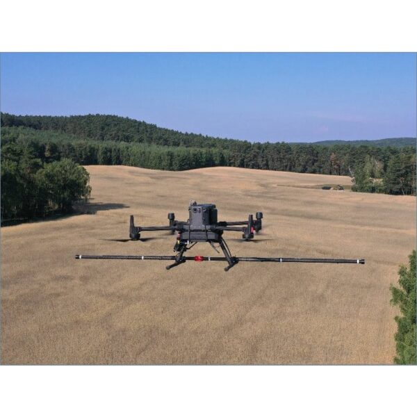
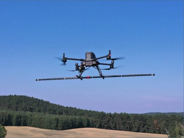
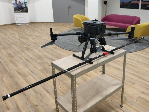
The SENSYS MagDrone R4 is an ultra-lightweight magnetometer that carries five triaxial fluxgate sensors on a 2 m horizontal bar, mounted on any UAV able to lift 2 kg. The five-sensor array covers a wide swath in a single pass for high-resolution magnetic mapping — the right tool for detecting small, compact buried objects and structures such as UXO and archaeological features, far faster than a single-sensor system.
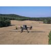
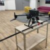
MagDrone R4 Installation on a DJI M300 RTK Drone

Five sensors, wide-swath high resolution
Where the single-sensor MagDrone R1 maps a narrow line, the R4’s 2 m bar of five triaxial fluxgates captures a wide, dense swath each pass. That dramatically increases coverage and resolution for high-detail mapping of small, compact targets — ideal for UXO detection and archaeological prospection over larger sites.

Light, drone-mounted and SkyHub-logged
At just 1.4 kg the sensor bar flies on DJI M350/M300 RTK and Inspired Flight IF800/IF1200A drones. It is powered by the drone and connects to the SkyHub onboard computer via the GPS-out interface for georeferenced logging. Fly as low as possible — a terrain-following system is recommended — and process the data in GeoHammer Pro or Seequent Oasis montaj.
Applications
Searching for UXO (unexploded ordnance), archaeological prospection, and surveying for ferrous objects of a few hundred grams or heavier lying underground — wherever high-resolution, wide-swath magnetic mapping is needed.
UXO & Detection Note
The system detects ferrous targets ranging from hand grenades (e.g. an estimated 0.5 m sensor-target distance for an F1 grenade) up to large UXO such as aerial bombs at a few metres. Magnetometers detect only items with a considerable amount of ferrous metal and cannot detect most modern landmines; the system must never be used to confirm the absence of landmines or ordnance, but is a valuable asset in Non-Technical or Technical Survey to confirm the presence of ferrous UXO.
Service & Warranty
Supplied by GulfNet Emirates Drone & Robotic Systems with UAE-based technical support, integration guidance and full manufacturer warranty. The MagDrone R4 requires the SkyHub onboard computer and additional components for drone operation — request a quote and our team will propose the complete, ready-to-fly magnetometer bundle, including a terrain-following system.
Key Specifications
| Sensor designation | FGM3D/75 |
| Number of sensors | 5 |
| Sensor technology | Fluxgate, triaxial |
| Sensor sensitivity | High |
| Sampling rate | 200 – 1,000 Hz |
| Dynamic range | ±75,000 nT |
| Configuration | Horizontal sensor bar, 2 m wide |
| Live data stream to ground | No (logged via SkyHub) |
| Power | Supplied from the drone (no internal battery) |
| Operating temperature | -20°C to +50°C |
| Ingress protection | IP52 |
| Supported drones | DJI M350 RTK / M300 RTK, Inspired Flight IF800 / IF1200A, or similar (min. 2 kg payload) |
| Weight | 1.4 kg |
| In the kit | MagDrone R4 magnetometer, MagDrone Data Tool software, power supply cable, USB cable, cable to SkyHub GPS-out, drone mountings, manual, transport hard case |
| SKU | IS-SENSYS-MAGDRONE-R4 |
Frequently Asked Questions
Where can I buy the SENSYS MagDrone R4 in Dubai?
You can buy the SENSYS MagDrone R4 Magnetometer directly through GulfNet Emirates, which supplies the payload from its Dubai office at Al Fattan Plaza. The unit ships as a ready-to-deploy kit that includes the 2 m five-sensor bar, MagDrone Data Tool software, SkyHub GPS-out cable, drone mountings, power and USB cables, manual, and a transport hard case. Because the R4 needs the SkyHub onboard computer and a terrain-following setup to fly properly, the GulfNet Emirates team scopes the full bundle before delivery rather than selling the sensor bar in isolation. Buyers across the Emirates can raise a request against SKU IS-SENSYS-MAGDRONE-R4 and coordinate installation on a DJI M350 RTK, M300 RTK, or Inspired Flight IF800 / IF1200A airframe.
How much is the SENSYS MagDrone R4 and what is the price in the UAE?
The SENSYS MagDrone R4 Magnetometer price UAE is quotation-based, not a fixed shelf number. This is because the payload is rarely sold as a standalone bar. The final SENSYS MagDrone R4 price in UAE depends on the SkyHub onboard computer, the GPS-out cable set, drone-side mountings for the M350 RTK or IF-series host, and the recommended terrain-following module. Processing software choice also shifts the sensys magdrone r4 magnetometer price, since teams working large UXO grids often add Seequent Oasis montaj alongside the included MagDrone Data Tool. GulfNet Emirates issues a written quote against SKU IS-SENSYS-MAGDRONE-R4 with a clear line-item breakdown, so procurement can compare hardware, cabling, software, and warranty coverage side by side before approval.
Is the SENSYS MagDrone R4 available in the UAE, and who sells it?
Yes. If you are asking who sells SENSYS MagDrone R4 in the UAE, the answer is GulfNet Emirates through its Drones & Robotic Solutions storefront. Stock status is listed as in-stock against SKU IS-SENSYS-MAGDRONE-R4, and buyers can buy sensys magdrone r4 magnetometer in UAE with local technical support, integration guidance, and the full manufacturer warranty covered end to end. Because the R4 is a specialised geophysical payload, GulfNet Emirates typically confirms the host UAV, ferrous-target profile, and survey environment before dispatch so the correct cabling and mounting kit ship with the bar. Delivery is coordinated from the Dubai office, with configuration advice provided for teams operating anywhere across the Emirates.
Who is the authorised SENSYS dealer in Dubai and distributor in the UAE?
GulfNet Emirates operates as the authorised SENSYS dealer Dubai buyers can approach for the MagDrone R4, alongside the wider SENSYS geophysical range. The same company acts as the SENSYS distributor UAE customers use for procurement, warranty registration, and post-sale technical assistance. As a SENSYS dealer UAE teams can rely on, GulfNet Emirates coordinates directly with SPH Engineering, the brand behind SkyHub and SENSYS integrations, to make sure the delivered configuration matches the drone airframe and survey workflow. The Al Fattan Plaza office in Dubai is the point of contact for demonstrations, integration training on DJI M350 / M300 RTK platforms, and follow-up support once the sensor bar is in operation.
How do I get a quote for the SENSYS MagDrone R4?
To get a quote for SENSYS MagDrone R4, use the Request a Quote form on the GulfNet Emirates DRS store, referencing SKU IS-SENSYS-MAGDRONE-R4. The listing is set up so the sensys magdrone r4 magnetometer for sale enquiry routes straight to the technical team, who then confirm which host UAV you plan to fly, whether you already own a SkyHub onboard computer, and whether a terrain-following system is required. That short discovery step matters because the R4 has no internal battery and no live downlink to the ground station, so cabling and logging setup must be scoped correctly. A written quote follows, covering the sensor bar, kit contents, integration items, and any optional processing software.
Can I book a demo, and is the SENSYS MagDrone R4 for sale in Dubai for immediate purchase?
Yes on both counts. Teams that want to book a SENSYS MagDrone R4 demo in Dubai can arrange one through the GulfNet Emirates Al Fattan Plaza office, where the payload is fitted to a DJI M350 RTK or M300 RTK for a live walkthrough of mounting, SkyHub connection, and MagDrone Data Tool logging. The SENSYS MagDrone R4 for sale in Dubai is dispatched from the same storefront, with the 1.4 kg five-sensor bar, cabling, drone mountings, manual, and transport hard case supplied as a complete kit. Buyers typically use the demo to validate swath width and target detection expectations against their own UXO or archaeological workflow before finalising the purchase order.
Which drones can carry the SENSYS MagDrone R4, and what is the payload requirement?
The R4 is designed for any UAV with a minimum 2 kg payload capacity. Officially supported airframes include the DJI M350 RTK, the DJI M300 RTK, and Inspired Flight IF800 and IF1200A drones. The sensor bar itself weighs 1.4 kg and is powered directly from the drone, with no internal battery on board. Logging runs through the SkyHub onboard computer via the GPS-out interface, so the host UAV must accept that integration. Because the 2 m horizontal bar sits below the aircraft, GulfNet Emirates recommends a terrain-following system to keep sensor-to-ground distance as low and consistent as possible. That combination is what allows the five triaxial fluxgates to deliver wide-swath, high-resolution magnetic maps in a single pass.
What is the best place to buy the SENSYS MagDrone R4 in the UAE, and is it a trusted seller?
For geophysical UAV payloads, the best place to buy SENSYS MagDrone R4 in the UAE is a distributor that can integrate the sensor with SkyHub and support it post-sale, not a general electronics reseller. GulfNet Emirates is positioned as a trusted seller of SENSYS MagDrone R4 in the UAE because it supplies the payload through its dedicated Drones & Robotic Solutions channel, provides UAE-based technical support, and backs each unit with the full manufacturer warranty. Buyers get access to integration guidance for the DJI M350 / M300 RTK and Inspired Flight airframes, along with recommendations on GeoHammer Pro and Seequent Oasis montaj for downstream processing, which few general suppliers can match.
Can I buy the SENSYS MagDrone R4 online in the UAE, and does GulfNet Emirates supply Abu Dhabi?
Yes. Buyers can buy SENSYS MagDrone R4 online in UAE through the GulfNet Emirates DRS store, where the payload is listed with a Request a Quote workflow rather than an add-to-cart price, because the final configuration depends on the host drone and SkyHub components. As a SENSYS MagDrone R4 supplier in Abu Dhabi, GulfNet Emirates handles orders placed by government, energy, and survey teams operating in the capital, coordinating delivery and setup from the Dubai office. The same channel is used by any SENSYS MagDrone R4 dealer in UAE enquiry, so procurement teams get a single point of contact for quotation, integration, warranty registration, and follow-up technical assistance on the fluxgate sensor bar.
How does the MagDrone R4 differ from the single-sensor R1, and when is it worth the upgrade?
The R1 carries one fluxgate sensor and maps a narrow line, while the R4 uses five triaxial FGM3D/75 fluxgates arranged on a 2 m horizontal bar. That layout captures a wide, dense swath in a single pass, which changes the economics of any large survey. For small UXO grids or one-off archaeological prospection, the R1 remains viable. Once site size grows, or the target profile shifts to small ferrous objects of a few hundred grams needing tight line spacing, the R4 pays back quickly by cutting flight hours and increasing resolution simultaneously. Sampling runs from 200 to 1,000 Hz with a dynamic range of ±75,000 nT, so detection performance on compact buried targets improves alongside the coverage gain.
What software is used to process MagDrone R4 data, and how does logging work in the field?
There is no live data stream to the ground station. The R4 logs through the SkyHub onboard computer, connected via the GPS-out interface, which georeferences every reading during flight. Once landed, the MagDrone Data Tool, included in the kit, handles the initial download and preparation. For interpretation, GulfNet Emirates recommends GeoHammer Pro for fast in-field processing and Seequent Oasis montaj for large-scale projects and formal deliverables. The payload operates from -20 °C to +50 °C with IP52 ingress protection, so field logging holds up across typical GCC survey conditions, from coastal sites in the Emirates to inland desert grids where archaeological or ferrous UXO targets are expected.
What are the main applications of the SENSYS MagDrone R4, and what are its detection limits?
The R4 is built for wide-swath, high-resolution magnetic mapping. Primary applications are UXO search, archaeological prospection, and general ferrous target survey where buried objects of a few hundred grams or more are of interest. Detection scales with target mass: an F1-type hand grenade is detectable at an estimated 0.5 m sensor-to-target distance, while large aerial bombs register at a few metres. The system reads only items with a considerable amount of ferrous metal, so it cannot detect most modern landmines and must never be used to confirm the absence of ordnance. In practice, the R4 is deployed as a confirmation and mapping asset within Non-Technical and Technical Survey workflows, not as a clearance tool.