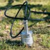
EchoLogger ECT D24S Dual-Frequency Echo Sounder for Shallow-Water Bathymetry
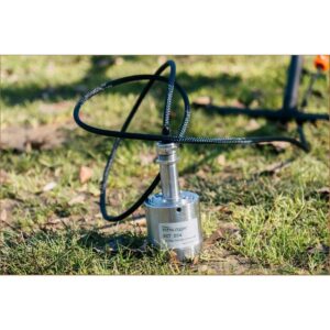
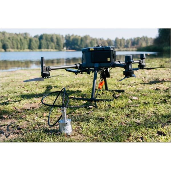
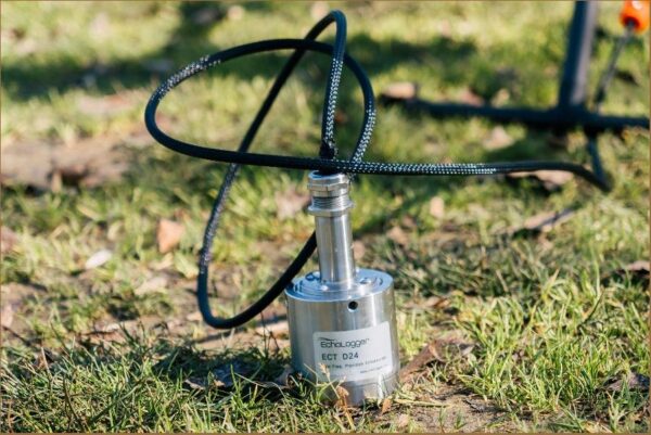
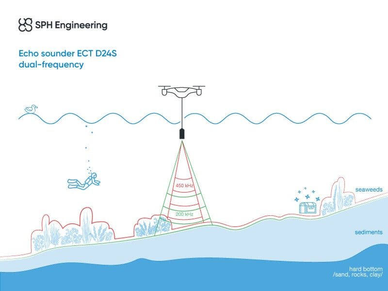
The EchoLogger ECT D24S is a dual-frequency UAV echo sounder tuned for shallow ponds, lakes and rivers — including weed-choked water that defeats other sounders. Its 200 kHz channel returns a continuous reflection from the bottom, while the 450 kHz channel covers very shallow areas where lower frequencies fail because of the dead zone. Drone-deployed and SkyHub-connected, it maps water depth from the air where boats cannot reach.
Echo Sounder ECT D24S Dual Frequency
Built for shallow, weedy water
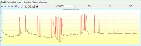
The 200/450 kHz pairing is the optimal combination for shallow ponds, lakes and rivers with heavy weed growth. 200 kHz reports a continuous bottom reflection, and 450 kHz reaches the shallowest areas where a single low frequency would be blinded by its dead zone — so you capture a clean depth profile end to end.
Light, field-ready and SkyHub-connected
At just 1.3 kg the D24S flies under DJI Matrice, Inspired Flight and WISPR enterprise UAVs. Integrated tilt and temperature sensors correct every reading, and the RS232 interface connects straight to SkyHub, which logs georeferenced depth data alongside UgCS flight automation for processing in DroneGIS.
Applications
Water-depth mapping and bathymetry, dredging planning and monitoring, tailings storage facility (TSF) monitoring, wastewater and stormwater surveying, and hydrology studies.
Service & Warranty
Supplied by GulfNet Emirates Drone & Robotic Systems with UAE-based technical support, integration guidance and full manufacturer warranty. The ECT D24S requires additional components and software for drone operation — request a quote and our team will propose the complete, ready-to-fly bathymetry kit.
Key Specifications
| Sensor type | SBES — single-beam, dual-frequency echo sounder |
| Acoustic frequency | 200 / 450 kHz |
| Measurement range | 0.5 – 200 m (200 kHz); 0.15 – 100 m (450 kHz) |
| Beam width | 10° / 5° conical (-3 dB) at 200 / 450 kHz |
| Range resolution | 1.0 mm |
| Accuracy | 0.2% of the depth measurement |
| Sediment measurement | No |
| Integrated tilt/roll sensor | Yes |
| Integrated temperature sensor | Yes |
| Supported drones | DJI M400 / M350 / M300, Inspired Flight IF800 / IF1200A, WISPR RangerPro |
| Cable length | 2.5 m |
| Echo sounder weight (in air) | 1.3 kg |
| All components weight (in air) | 1.9 kg |
| In the kit | Echo sounder, harness with carabiner, stainless-steel housing, RS232 data cable with SkyHub connector, transport hard case |
| SKU | IS-EL-ECT-D24S |
Frequently Asked Questions
Where can I buy the Echologger ECT D24S in Dubai?
GulfNet Emirates Drone & Robotic Solutions supplies the EchoLogger ECT D24S from its Dubai office at Al Fattan Plaza, Office 607. As an appointed channel for SPH Engineering payloads in the region, the team handles procurement, integration advice for DJI Matrice, Inspired Flight and WISPR RangerPro aircraft, and hand-over with UAE-based technical support. Because the D24S needs the SkyHub onboard computer and UgCS flight planning software to fly a bathymetry mission, orders are configured as complete kits rather than a bare sensor. Buyers in the UAE typically request a quote through the product listing or the Dubai office and receive a full bill of materials matched to their drone platform and survey scope.
How much is the Echologger ECT D24S, and what drives the price in the UAE?
The EchoLogger ECT D24S Dual-Frequency Echo Sounder price is not published as a single sticker figure because the sensor rarely ships alone. Each Echologger ECT D24S price in UAE quotes covers the echo sounder itself, harness with carabiner, stainless-steel housing, RS232 data cable with SkyHub connector and the transport hard case, plus any SkyHub hardware, UgCS licences and DroneGIS processing seats you still need. Aircraft compatibility, RTK requirements and training hours also affect the final number. Submitting a request through the GulfNet Emirates listing returns a costed proposal in AED with the exact combination scoped for your survey workflow.
Is the Echologger ECT D24S available in the UAE right now?
Yes. Is Echologger ECT D24S available in the UAE is a common check from bathymetry teams, and stock is held or sourced on request through GulfNet Emirates. The EchoLogger ECT D24S Dual-Frequency Echo Sounder is listed as in-stock on the DRS store under the Payloads & Sensors category, with the SKU IS-EL-ECT-D24S. Because the unit is often paired with SkyHub, cabling and a specific DJI M400, M350, M300, Inspired Flight IF800 or IF1200A, or WISPR RangerPro airframe, confirmed lead times are shared with the quote. That way the delivered box matches the aircraft you already fly.
Who sells the Echologger ECT D24S in the UAE?
The buyer question of who sells Echologger ECT D24S in the UAE routes to GulfNet Emirates, which positions itself as an Echologger ECT D24S dealer in UAE for SPH Engineering payloads. Acting as an EchoLogger dealer UAE, the team scopes the sensor together with the SkyHub controller, RS232 harness and UgCS mission plans that make the payload actually fly a survey. That is the practical difference from a generic parts reseller: the D24S is quoted as an operational bathymetry package for DJI Matrice, Inspired Flight or WISPR RangerPro platforms rather than a standalone sonar head shipped in a box.
What is the best place to buy the Echologger ECT D24S in the UAE?
For hydrographers, dredging contractors and TSF monitoring teams, the best place to buy Echologger ECT D24S in the UAE is a supplier that can integrate the sensor with a supported drone and hand over a working mission workflow, not just a shipping label. GulfNet Emirates fits that brief and is treated by regional operators as a trusted seller of Echologger ECT D24S in the UAE. The Dubai team provides the sensor with its harness, stainless-steel housing, RS232 SkyHub cable and hard case, and pairs it with SkyHub, UgCS and DroneGIS so shallow-water surveys start producing georeferenced depth data on the first flight.
Is there an Echologger ECT D24S supplier in Abu Dhabi?
GulfNet Emirates services Abu Dhabi from its Dubai base and acts as the Echologger ECT D24S supplier in Abu Dhabi for government, utility and consulting clients running shallow-water mapping projects. As an EchoLogger distributor UAE, the team can coordinate delivery, on-site integration and training across the emirates. Typical Abu Dhabi use cases include wastewater and stormwater surveying, dredging planning around the coastline and tailings storage facility monitoring at industrial sites. Because the D24S is tuned for shallow, weedy water and reads 0.15 m to 200 m depending on frequency, it suits inland ponds and lagoons that boat-mounted sounders struggle to access.
Can I buy the Echologger ECT D24S online in UAE, or is it enquiry only?
You can buy Echologger ECT D24S online in UAE through the GulfNet Emirates DRS storefront, but the checkout runs on a quotation model rather than a fixed-price add-to-cart. The listing carries a Request a Quote action instead of a live AED price. That is standard practice when you buy EchoLogger ECT D24S Dual-Frequency Echo Sounder units because most orders bundle SkyHub, UgCS and DroneGIS with specific cabling for a DJI Matrice, Inspired Flight or WISPR airframe. Submitting the online request confirms availability, locks the specification and returns a formal proposal for approval before payment and dispatch.
How do I get a quote for the Echologger ECT D24S from GulfNet Emirates?
To get a quote for Echologger ECT D24S, use the Request a Quote button on the product listing or the general enquiry form on the DRS site. The team asks which drone you fly (M400, M350, M300, IF800, IF1200A or RangerPro), whether you already own SkyHub or UgCS, and the survey depths and water types involved. A structured EchoLogger ECT D24S Dual-Frequency Echo Sounder price UAE proposal comes back with the sensor kit, integration components, software licences and any training. This scoping step is what prevents you from receiving a sensor that cannot fly a mission on arrival.
Can I book an Echologger ECT D24S demo in Dubai before purchase?
Yes. Buyers can book an Echologger ECT D24S demo in Dubai through GulfNet Emirates, which operates as an authorised EchoLogger dealer Dubai for SPH Engineering payloads. Demos usually cover mounting the 1.3 kg sensor under a supported DJI Matrice or Inspired Flight airframe, running a short SkyHub-logged mission and walking through the 200 kHz and 450 kHz echograms so surveyors can see how the dual channels handle very shallow, weed-affected water. This is the fastest way to confirm the D24S is the right choice against alternatives like the deeper-water D052S before signing off on procurement.
Which drones does the Echologger ECT D24S work with, and why does that matter at purchase time?
The EchoLogger ECT D24S Dual-Frequency Echo Sounder for sale through GulfNet Emirates is qualified for DJI M400, M350 and M300, Inspired Flight IF800 and IF1200A, and WISPR RangerPro. All-up payload weight sits at 1.9 kg for the full component set, with the sensor itself at 1.3 kg in air, so airframe payload budget is the first thing checked during quoting. Buyers already flying one of these platforms can reuse their aircraft, RC and batteries. Teams on other drones may need to add a supported airframe to the order, which is why the drone question is asked before pricing.
What is included in the box when you buy the EchoLogger ECT D24S Dual-Frequency Echo Sounder?
The standard delivery for the EchoLogger ECT D24S covers the echo sounder head, harness with carabiner, stainless-steel housing, RS232 data cable with SkyHub connector and a transport hard case, all under SKU IS-EL-ECT-D24S. Not included, and quoted separately, are the SkyHub onboard computer, UgCS flight planning licence, DroneGIS processing software and the drone itself. GulfNet Emirates supplies the unit with UAE-based technical support, integration guidance and full manufacturer warranty from SPH Engineering, so faults and RMAs are handled locally rather than being routed back to Europe by the end user.
Where can teams find the Echologger ECT D24S for sale in Dubai for shallow-water bathymetry projects?
The Echologger ECT D24S for sale in Dubai is listed by GulfNet Emirates under Payloads & Sensors in the DRS catalogue, aimed at teams running shallow ponds, lakes and weed-choked river surveys. The dual 200/450 kHz configuration is what makes it a fit: the 200 kHz channel gives a continuous bottom return, while 450 kHz reaches into the very shallow zone where a single low frequency is blinded by its own dead zone. Typical buyers in the UAE apply it to dredging planning and monitoring, tailings storage facility surveys, wastewater and stormwater mapping, and hydrology studies where boats simply cannot get in.