A vehicle breaks down 80 kilometres into the Empty Quarter. A hiker loses the trail near Jebel Jais as the day gets short. A workman does not return from a remote infrastructure site. In each scenario the clock begins ticking right away – and in the UAE’s extreme climate, that clock moves fast.
Traditional search methods face a brutal reality: Ground teams are slow to move over difficult terrain, helicopters are costly and not always readily available and the search area often covers hundreds of square kilometres. The question is not whether to search – it’s whether you can search fast enough.
This is where enterprise-grade drone technology is changing things. The same thermal imaging, high-speed deployment and intelligent flight systems that have been used in the inspection of refineries and the monitoring of critical infrastructure are now proving invaluable in humanitarian operations.
Search and rescue coordinators based in the UAE experience a very distinctive set of challenges which means that every operation is a race against time.
Vast, Featureless Terrain
The desert landscapes of the UAE provide very little visual landmarks. A missing person can be only 500 metres away from a search team, and be completely invisible behind the dunes which all look identical from ground level. Traditional grid searches are methodical but painfully slow – and in 45degC heat, slow can be fatal.
Extreme Climate Conditions
Dehydration and heat stroke become critical threats within hours, not days. Night searches offer relief from heat but eliminate visual detection entirely. Ground teams face the same environmental hazards as the people they’re searching for, limiting how long they can safely operate.
Remote and Inaccessible Locations
Mountain terrain, coastal mangroves, and industrial zones in remote areas present access challenges that delay response. By the time ground vehicles navigate to a search area, critical time has already been lost.
Coordination Complexity
Multiple agencies, limited communication infrastructure in remote areas, and the pressure of families waiting for news create an environment where actionable intelligence is worth more than additional personnel.
The technology deployed for industrial inspection – thermal sensors, autonomous flight systems, rapid mobilisation protocols, and intelligent data processing – translates directly into search and rescue effectiveness.
Thermal Imaging That Sees What Eyes Cannot
The same types of radiometric thermal cameras that are used to detect hotspots on flare stacks and anomalies in solar arrays, can identify human heat signatures from altitude. A person lying unconscious behind a dune, invisible to ground searchers, presents a clear thermal signature from 100 metres above. Night operations become not just possible but often more effective, as thermal contrast increases when ambient temperatures drop.
This isn’t consumer-grade equipment. Industrial thermal payloads with temperature sensitivity and range designed for infrastructure inspection provide the detection capability that search operations demand.
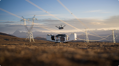
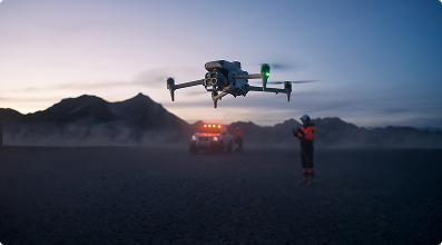
Rapid Deployment When Minutes Matter
Enterprise drone operations are based on quick mobilisation. Teams that are used to deploying for emergency industrial inspections – a pipeline incident, a facility that needs to be assessed immediately – bring the same urgency to search and rescue. Equipment staged for quick response, pilots certified for immediate deployment, and logistics refined through hundreds of industrial operations translate directly to faster airborne search capability.
In practical terms, this means aerial search operations can commence within hours of activation, not days.
Systematic Coverage at Scale
Autonomous flight planning ensures complete, gap-free coverage of search areas. The same mission planning software used to survey kilometres of pipeline corridors or map large construction sites creates efficient search patterns that methodically cover terrain without the overlap and gaps inherent in manual searching.
A single drone covering several square kilometres per hour can survey terrain that would occupy dozens of ground personnel for an entire day. When multiplied across a coordinated operation, the mathematics of search probability shift dramatically.
Reaching Terrain That Stops Ground Teams
Drones fly where vehicles cannot drive and where sending personnel would create additional risk. Steep ravines, unstable post-incident terrain, areas requiring hazmat assessment before human entry – aerial platforms provide intelligence without exposure. This is standard practice in industrial inspection, and the capability serves equally well in humanitarian contexts.
Real-Time Intelligence for Decision Makers
Live video feeds streamed to command centres give search coordinators immediate visibility into terrain conditions, potential sighting locations, and resource deployment effectiveness. The same data platforms used to deliver industrial inspection insights – centralised access, annotation capabilities, stakeholder sharing – support coordination across multiple agencies working a search operation.
Locating a missing person is only half the battle. In remote terrain it can take hours for ground teams to make visual contact with a drone. Payload-equipped platforms can provide immediate assistance – water, emergency communication devices, first aid supplies, thermal blankets – providing much-needed time while extraction teams get to the location.
This capability requires the same payload integration knowledge that is used in industrial applications, knowledge of weight limitations, flight characteristics with cargo, and release mechanisms. Enterprise platforms designed for sensor payloads adapt readily to emergency supply delivery.
What makes drone-assisted search and rescue possible today isn’t a breakthrough in new technology – it’s the ripeness of capabilities developed for industrial applications. Thermal sensors improved by thousands of infrastructure inspections. Flight systems with a proven record in challenging operational settings. Deployment protocols that are optimised for rapid reaction. Data platforms developed for actionable intelligence delivery.
The expertise needed to inspect a flare stack at 150 metres, survey a remote pipeline corridor or monitor a solar farm in desert conditions is directly applicable to search and rescue operations. The platforms are the same. The sensors are the same. The operational discipline is the same. Only the mission changes.
For operators with enterprise-grade capabilities, search and rescue represents something beyond a service offering. It’s an opportunity to apply sophisticated technology where it matters most – when lives are at stake and families are waiting.
The UAE has consistently invested in advanced emergency response infrastructure. Drone technology adds a capability layer that complements existing resources, extending reach and accelerating timelines without replacing the expertise of dedicated rescue professionals.
When someone goes missing in the UAE’s challenging terrain, the response requires speed, coverage, and detection capability that traditional methods struggle to deliver. Enterprise drone technology – thermal imaging, rapid deployment, systematic aerial coverage, and real-time intelligence – provides advantages that directly address these challenges.
The same capabilities that make drones invaluable for industrial inspection make them equally valuable when the mission shifts from protecting assets to saving lives. And ultimately, that may be the most meaningful application of this technology.
Thermal cameras detect body heat signatures that are invisible to the human eye, enabling detection even when a person is hidden behind terrain features, lying in vegetation, or unconscious and unable to signal. Thermal detection is particularly effective during night operations when temperature contrast between the human body and the environment increases.
With equipment staged for rapid response and pilots certified for immediate deployment, aerial search operations can typically commence within 1-2 hours of activation. Autonomous drone systems positioned at strategic locations can launch within minutes, beginning systematic search patterns while ground teams are still mobilising.
Enterprise-grade drones are engineered for the UAE’s demanding environment – extreme heat, dust, wind, and varied terrain from desert dunes to mountain elevations. The same platforms proven in industrial inspection across refineries, offshore installations, and remote infrastructure sites maintain reliable operation in search and rescue conditions.
Yes. Payload-equipped drones can deliver water, first aid supplies, communication devices, and emergency beacons to individuals in remote locations. This capability can provide critical support during the time gap between aerial location and ground team arrival – particularly important in extreme heat conditions.
Drone operations integrate with existing command structures through real-time video feeds streamed to coordination centres, shared data platforms accessible to multiple agencies, and direct communication with ground teams. The technology supports rescue professionals with aerial intelligence rather than operating independently.
 Go back