Inspection Challenge Across Construction Sector

Construction projects across the GCC operate under compressed timelines, evolving site conditions, and multi-stakeholder coordination demands. Traditional inspection methods struggle to deliver the visibility, accuracy, and safety that modern project delivery requires.

high-access-risk
Height Access Risks

Manual roof and facade inspections expose crews to fall hazards.

progress-blind-spots
Progress Blind Spots

Large or phased sites make accurate schedule tracking difficult to maintain.

construction-circle
quantity-insiconsistecy
Quantity Inconsistencies

Conventional stockpile measurements create delays and reporting discrepancies.

fragmented-data
Fragmented Data

Dispersed inspection records limit centralized oversight and timely decision-making.

Our Drone Services for Construction

Certified operations delivering survey-grade data for project teams.

construction-progress-monitouring

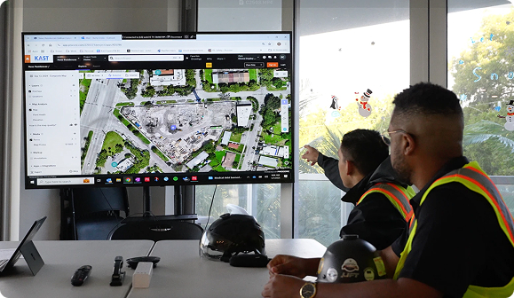
Construction Progress Monitoring

Our periodic UAV flights capture site-wide activities using predefined paths, enabling objective visual comparison of construction advancement over time. 

  • Time-stamped imagery for milestone documentation 
  • Repeatable flight paths ensure consistent comparison
  • Visual datasets support schedule verification 
  • Reduced reliance on manual site walks
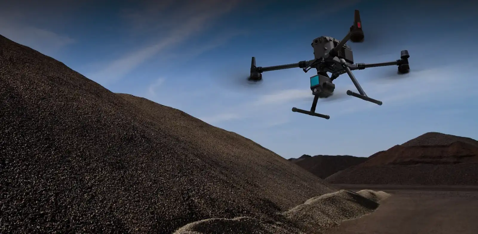
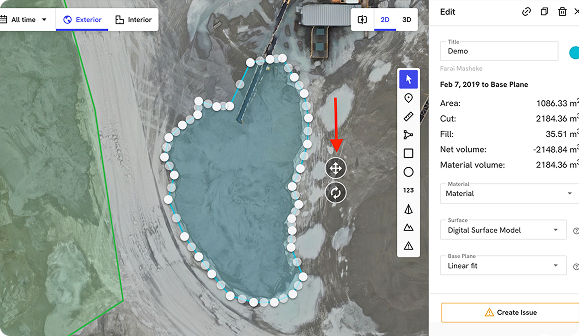
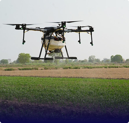
stockpile-survey

Stockpile Survey

Photogrammetry-based volumetric capture generates accurate material measurements without disrupting ongoing operations or requiring manual calculations.

  • Precise volume outputs in cubic metres 
  • Inventory verification without production interruption 
  • Historical comparison for usage tracking 
  • Supports accurate progress billing submissions
3d-mapping-tapography

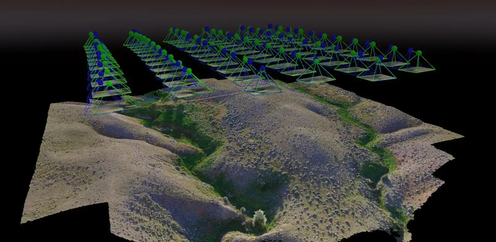
3D Mapping and Topography

UAV imagery processed into point clouds, orthomosaics, and terrain models provides measurement-ready datasets for planning and as-built validation.

  • Digital elevation and surface models generated
  • Contour mapping supports earthwork planning
  • Geospatial data compatible with design software
  • Cut-and-fill analysis for excavation tracking
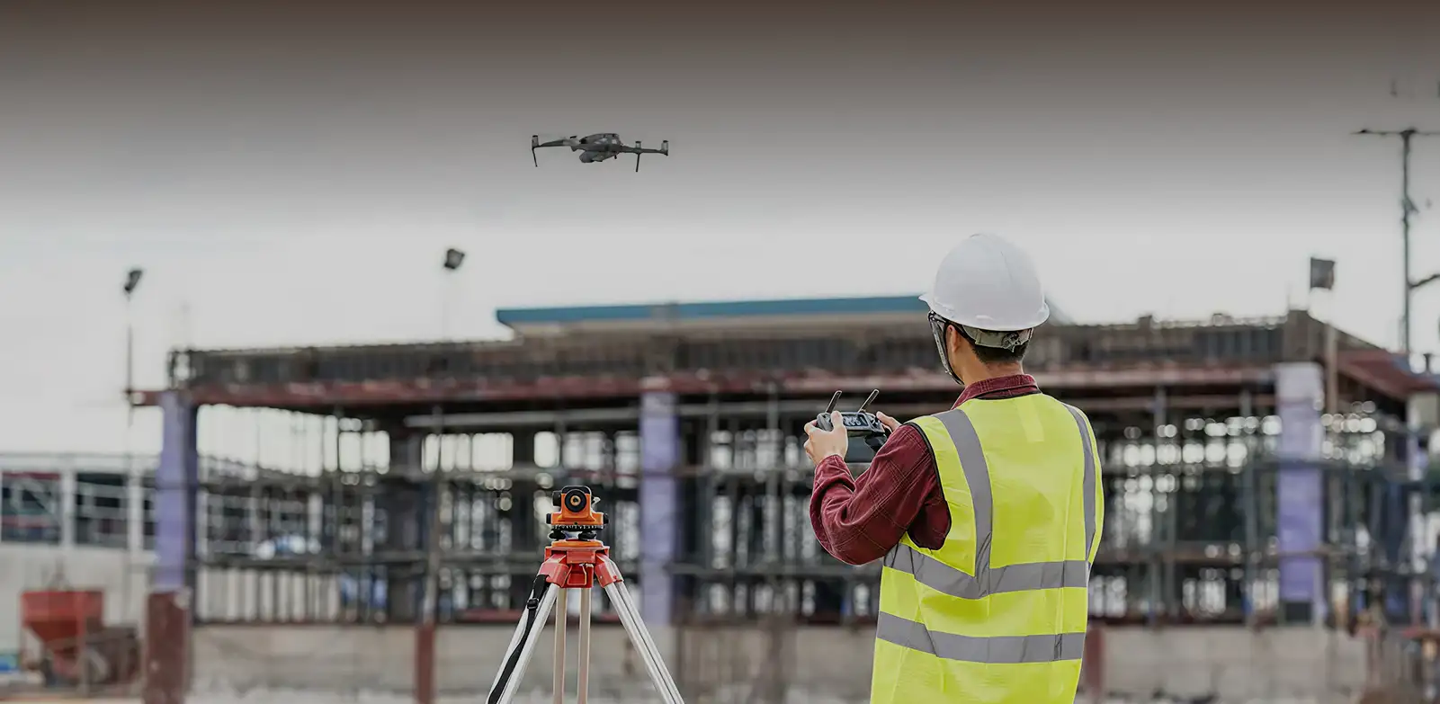
build-inspection

Building Inspection

Vertical and oblique drone flights document roof and facade conditions without scaffolding, rope access, or operational disruption.

  • High-resolution defect documentation captured
  • Exterior assessments completed without building downtime 
  • Cladding and sealant conditions recorded visually
  • Safe alternative to manual height access

Gulfnet Insight® Turning Inspection Data Into Decisions

Your centralized platform for accessing, reviewing, and acting on aerial inspection outputs.

Inspection imagery organized by project location.
Array

Side-by-side visual tracking over time.
Array

Distance and area calculations on-screen.
Array

Controlled access for project team members.
Array
centralied-access

Aging assets won't wait - schedule your construction site assessment now.

Other Industries

Frequently Asked Questions

Flight frequency depends on project pace and reporting requirements. Most construction teams schedule weekly construction monitoring drone flights during active phases to maintain consistent progress documentation. Milestone-based flights work well for projects with defined stages. Reliable drone construction monitoring programs also adapt to seasonal factors, workforce shifts and client reporting cycles. Our team works with you to establish a monitoring schedule that aligns with your project timeline and stakeholder reporting needs. Adjustments can be made as project conditions evolve.

Get in touch with us today to learn more about our drone inspection services and related cost savings.

Drone-based photogrammetry typically delivers volume accuracy within one to three percent when proper ground control points are deployed, making construction drone mapping one of the most reliable methods for earthwork and material quantification on active sites. This level of precision supports reliable inventory tracking and progress billing documentation. Accuracy depends on factors including terrain complexity and survey methodology. Our operations follow established survey standards to ensure measurements are consistent and defensible for reporting purposes. As one of the best drone mapping services for construction projects in the GCC, Gulfnet can discuss specific accuracy requirements during project scoping.

Looking for reliable drone inspection services in the GCC? Get in touch with our experts today for a free consultation.

Yes. Construction site drones are designed to work around active site conditions. Flights are planned to avoid interference with ongoing construction activities and can be scheduled during lower-activity periods when preferred. Deploying a drone for construction site data capture is non-intrusive, meaning personnel and equipment continue operating while imagery is collected overhead. Site coordination is handled in advance to ensure smooth execution.

For best results, get in touch with our experts today.

Deliverables vary based on the construction drone services engaged. Progress monitoring typically includes time-stamped imagery and visual comparison datasets. Stockpile surveys provide volume measurements and inventory verification reports. Topography and mapping services deliver orthomosaics, digital elevation models, contour maps, and cut-fill analysis. Building inspections generate high-resolution condition documentation and defect reference imagery. Gulfnet deploys the best drone for construction data capture across every service type, and all outputs are accessible through Gulfnet Insight(R), allowing your team to review, measure, and share data as needed.

Get in touch with our experts today to get solutions that best fit your needs.

Absolutely. As one of the leading construction drone companies in the region, all Gulfnet operations are executed in compliance with applicable aviation authority regulations across the GCC, including GCAA requirements in the UAE and GACA requirements in Saudi Arabia. Our pilots hold required certifications, and permits are secured in advance for each project location. Regulatory compliance is managed as part of our standard project delivery process. When you partner with Gulfnet, you get certified experts who understand industry-specific requirements and deliver excellent results on drones for construction projects of all scales.

Drone surveying for construction covers large areas significantly faster than ground-based methods while reducing personnel exposure to site hazards. A site that might require weeks using conventional techniques can often be captured in a single day with aerial operations. Data processing delivers measurement-ready outputs without the manual calculations required by traditional approaches. For structural assessments, the best drone for construction inspection platforms capture detail that ground crews cannot safely access. The speed and repeatability of drone surveys support more frequent data capture, giving project teams better visibility into site conditions throughout the construction lifecycle.

Yes. Drone filming for construction progress provides stakeholders with visual timelines that document every phase from foundation to handover, giving project owners, investors and consultants a verifiable record of site evolution. Beyond progress capture, drone inspection for building maintenance enables detailed assessment of facades, curtain walls, roofing systems, waterproofing membranes and structural joints without scaffolding or rope access. High-resolution and thermal imagery identifies defects such as cracking, delamination, moisture ingress and insulation failure that are difficult to detect from ground level. Gulfnet delivers annotated inspection reports with defect classifications and recommended remediation actions that feed directly into your maintenance planning workflows.

Deploying a drone for construction site inspection eliminates the need for workers to access hazardous elevated positions, confined spaces and unstable structures for visual assessment and documentation. Fall-from-height incidents remain one of the leading causes of construction fatalities across the GCC, and aerial data capture removes personnel from these high-risk environments entirely. Our construction drone services also support HSE compliance by providing documented visual evidence of safety barrier conditions, PPE usage across zones and housekeeping standards. Site managers use the data for toolbox talks, incident investigations and audit preparation, turning inspection outputs into a proactive safety management resource.

Construction drone mapping is one of the most efficient methods for pre-construction site documentation. Our UAV platforms capture high-resolution aerial imagery and LiDAR data that is processed into digital terrain models, contour maps, cut-fill calculations and georeferenced orthomosaics. This baseline data supports earthwork planning, drainage design, access road layout and foundation engineering. Drone surveying for construction at the pre-build stage also identifies topographic risks such as slope instability, flood-prone zones and underground utility conflicts that traditional surveys may miss. All outputs are delivered in formats compatible with CAD, BIM and GIS platforms, giving your design and engineering teams a precise digital foundation for project planning.

The best drone for construction quality assurance programs combines high-resolution visual capture with thermal and photogrammetric analysis to identify workmanship defects, material failures and specification deviations during active build phases. Thermal imaging reveals moisture intrusion behind cladding, HVAC duct leakage and insulation gaps before finishes conceal them permanently. Photogrammetric comparison against BIM models highlights dimensional variances and alignment issues in structural and MEP installations. The best drone for construction inspection workflows enable project teams to document non-conformances with geo-tagged imagery and defect severity ratings, streamlining the snag list process and providing auditable evidence for contractor accountability and client handover documentation.

Yes. Gulfnet provides some of the best drone mapping services for construction projects that require BIM integration. Photogrammetric point clouds and orthomosaics generated from drone surveys are exported in industry-standard formats including LAS, E57, GeoTIFF and OBJ, allowing direct overlay with BIM models in platforms such as Autodesk Revit, Navisworks and Bentley. This enables design-versus-built comparison, clash detection and progress verification against planned schedules. Construction site drones capture data frequently enough to support 4D BIM timelines, giving project managers a visual and dimensional record of how the physical build tracks against the digital model at every stage.

When evaluating construction drone companies, look for demonstrated experience across the specific project types relevant to your portfolio, whether that is high-rise towers, infrastructure corridors, industrial facilities or master-planned communities. Key differentiators include regulatory compliance track record, sensor and platform versatility, data processing capabilities and integration support with your existing project management systems. Reliable drone construction monitoring providers also offer scalable programs that adapt to your project phases rather than delivering one-off flights. Gulfnet operates an enterprise-grade fleet with GCAA-certified pilots, in-house data processing and a cloud delivery platform, providing end-to-end capability from mission planning through to actionable deliverables.

Yes. Gulfnet designs multi-site construction monitoring drone programs that provide consistent, standardized data capture across your entire portfolio, whether that spans two sites or twenty across the GCC. Each site receives a tailored flight schedule aligned to its construction phase, reporting cycle and stakeholder requirements. Drone filming for construction progress across a portfolio enables centralized dashboards where leadership teams compare milestone completion, resource deployment and site conditions side by side. Data from all sites is accessible through Gulfnet Insight(R) with role-based permissions, ensuring project managers, consultants and clients see the information relevant to them without delays or manual report distribution.

Absolutely. Drone inspection for building maintenance readiness is a critical component of the handover process, and aerial inspection captures the as-built condition of roofing, facades, external MEP installations and landscaping before the defects liability period begins. High-resolution imagery and thermal scans create a baseline condition record that protects both the developer and contractor by documenting the state of every external element at practical completion. Drones for construction projects also generate final as-built orthomosaics, 3D models and elevation data that update the project digital twin for facilities management teams. This handover package gives building owners a comprehensive asset baseline from day one, supporting warranty claims, planned maintenance scheduling and future renovation planning.

Share your asset list and inspection priorities
to receive a tailored scope and plan.

Request our capabilities deck and platform walkthrough to see reporting and workflows.