Frequently Asked Questions
Where to shop for drones and robots online in the UAE?
The GulfNet Emirates DRS store operates as a dedicated online drone store UAE buyers can use to source enterprise drones, robotics, cameras, and software licences under one roof. The catalogue spans DJI enterprise and Agras platforms, Unitree humanoid and quadruped robots, QYSEA underwater ROVs, AVIX bird deterrent systems, RTK stations, docking stations, payloads, and photogrammetry software such as Agisoft Metashape and Pixxel Aurora. Products are listed with clear pricing in AED or a Request a Quote route for enterprise SKUs, and orders are handled from the Dubai office at Al Fattan Plaza. For buyers who need consultation before committing, the store also links directly to a quote form and support contact.
Which UAE store sells industrial drones and robots under a single account?
GulfNet Emirates runs a consolidated industrial drone shop UAE operators can use for both aerial platforms and ground or underwater robotics. On the aerial side, the catalogue includes DJI Matrice enterprise drones, DJI Agras T25, T25P, T50, T70P and T100 agricultural drones, DJI FlyCart 100 heavy-lift delivery drone, Flyability Elios 3 for confined spaces, and Flybotix ASIO X. On the robotics side, buyers get Unitree R1, G1 and H1 humanoids alongside Go2 and B2 quadrupeds, plus QYSEA FIFISH ROVs for underwater work. Supporting hardware such as DJI Dock 3 Overseas Edition, D-RTK 3, and BS100 battery station is stocked alongside, so procurement teams avoid juggling multiple vendors.
What is the best online drone shop in Dubai for enterprise buyers?
For enterprise procurement, the GulfNet Emirates drone store Dubai buyers rely on offers three things that matter to B2B teams: authorised distribution, on-site inventory, and structured quoting. The store lists 84 SKUs across drones, payloads, robotics, cameras, imaging, and software licences, with fixed AED pricing on stocked items such as the DJI BS100 at AED 4,267, DJI D-RTK 3 at AED 5,107, and DJI Dock 3 Overseas Edition at AED 52,101. Higher-value platforms like the Agras series, FlyCart 100, and Unitree humanoids route through a Request a Quote workflow so specifications, training, and delivery can be aligned before purchase. The Dubai office at Al Fattan Plaza handles account setup and after-sale coordination.
Can I buy drones and robots online with UAE delivery from one supplier?
Yes. GulfNet Emirates handles orders end to end, so customers can buy drones and robots online UAE-wide without splitting procurement across multiple resellers. The storefront supports direct add-to-cart checkout in AED for stocked items and a Request a Quote flow for configured enterprise packages such as the DJI Agras T100, DJI FlyCart 100, Unitree humanoids, Flyability Elios 3, and QYSEA FIFISH ROVs. Shipping and delivery terms are published in a dedicated policy section, and returns plus warranty coverage are documented separately. Buyers based outside Dubai, including Abu Dhabi and the northern emirates, coordinate delivery through the same Dubai office and support line.
Does the store carry UAV equipment suitable for Abu Dhabi projects?
The GulfNet Emirates catalogue effectively functions as a UAV equipment store Abu Dhabi survey, inspection, energy, and public-safety teams can source from. Ground-control and RTK infrastructure such as the DJI D-RTK 3 Multifunctional Station supports precise mapping missions, while the DJI Dock 3 Overseas Edition enables remote and vehicle-mounted autonomous deployment. Enterprise airframes suited to Abu Dhabi workflows include DJI Matrice-class platforms, the confined-space Flyability Elios 3, and the FlyCart 100 for logistics. Payloads, gimbals, cameras, batteries, and memory are stocked in the Cameras & Imaging and Payloads & Sensors sections, so Abu Dhabi operators can complete a full kit through one supplier.
What robotics products are available in the online robotics shop UAE section?
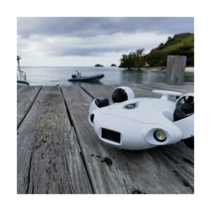
The robotics online shop UAE segment of the catalogue is split across humanoid robots, quadruped robots, underwater ROVs, autonomous systems, and cleaning systems. Humanoids include the Unitree R1, G1, and H1 for research, demonstration, and integration work. Quadrupeds cover the Unitree Go2 and B2 for inspection, security, and payload-carrying tasks. Underwater operations are served by the QYSEA FIFISH range of ROVs, aimed at inspection, survey, and rescue use cases in ports, offshore assets, and desalination plants. Autonomous machines and cleaning systems round out the range for industrial automation programmes. Each SKU routes to a Request a Quote form so the specification, training, and integration scope can be locked before order.
How do I request a quote for high-value drones or robots?
Any product listing without a fixed cart price includes a Request a Quote button that pre-fills the product name and sends the enquiry to the GulfNet Emirates sales team in Dubai. This flow is standard for the DJI Agras T25, T25P, T50, T70P, T100, DJI FlyCart 100, DJI Avata 2 Fly More Combo, Unitree humanoids, and full robotics packages. Buyers can also submit a general quote request through the top navigation, or contact the office directly on +971-4-8972598 or through the published email. This route is preferred for bundled deals that combine airframes with payloads, docks, batteries, software licences, and training.
What software licences can I purchase alongside a drone order?
The Software Licenses section groups tools by workflow: Fleet & Operations, Mapping & Photogrammetry, Reality Capture, Flight Planning, Delivery Management, and Licences & Subscriptions. Confirmed listings include Agisoft Metashape Professional Edition from AED 12,850 per licence, Agisoft Metashape Standard Edition from AED 657 per licence, and Aurora by Pixxel, a no-code cloud-native Earth Observation Studio for tasking satellites and analysing archives. This lets survey, GIS, and mission-planning teams pair software directly with the airframes and payloads they buy, so photogrammetry, orthomosaic, DEM, and satellite analysis pipelines are covered without sourcing licences separately from other vendors.
Which docks, RTK stations, and batteries are stocked for autonomous drone operations?
Autonomous and BVLOS-ready infrastructure is covered under Docks & Drone-in-a-Box Stations and RTK & Accessories. Confirmed listings include the DJI Dock 3 Overseas Edition at AED 52,101, described as DJI's first dock built to deploy on a moving vehicle, and the DJI D-RTK 3 Multifunctional Station at AED 5,107, a rugged GNSS unit that works as three stations in one setup. For power logistics on Matrice 400 deployments, the DJI BS100 Intelligent Battery Station is stocked at AED 4,267 and serves as a combined charging, storage, and transport hub. Together these units let operators run dock-based, vehicle-mounted, and field-charged missions from one supplier.
Are cameras, gimbals, and imaging accessories available for cinematography teams?
The Cameras & Imaging section is built for professional video and inspection teams, not just drone pilots. It splits into Cinema & Mirrorless Cameras, Gimbals & Stabilisers, Action Cameras, Lenses, Lighting & Audio, and Memory & Power. That means a Dubai or GCC production house can source a full acquisition kit alongside its airframe, including the DJI Avata 2 Fly More Combo listed for immersive 4K/60fps low-altitude FPV work with DJI Goggles 3 and RC Motion 3. Pairing cameras, gimbals, storage, and drone platforms in one order simplifies logistics for film, broadcast, and industrial documentation projects handled out of the UAE.
What bird deterrent and site-protection products are listed?
Under the AVIX brand, the store lists three automated laser bird deterrents. The AVIX Autonomic Mark II is the flagship automated laser bird repellent, configured once and then set to sweep the site 24/7 to reduce bird presence. The AVIX Handheld, formerly Agrilaser Handheld, is a portable green-laser deterrent aimed by hand for immediate response. The AVIX Indoor is a plug-and-play Class 2M automated laser for closed warehouses, logistics facilities, and food-storage environments. This mix supports airports, farms, aquaculture, industrial sites, and food-grade indoor spaces across the UAE and wider GCC that need a non-lethal, low-labour bird management method.
How is pricing displayed and what payment currency is used?
Prices on stocked items are displayed in United Arab Emirates dirham. The default cart totals in AED, and confirmed listed prices include the DJI BS100 Intelligent Battery Station at AED 4,267, the DJI D-RTK 3 Multifunctional Station at AED 5,107, and the DJI Dock 3 Overseas Edition at AED 52,101. Software licences carry starting prices such as Agisoft Metashape Professional Edition from AED 12,850 per licence and Standard Edition from AED 657 per licence. Products without a listed price, including most Agras, FlyCart, Unitree, Flyability, and QYSEA units, use a Request a Quote workflow so the final AED figure is aligned with configuration and volume before order confirmation.