If you are managing a construction project in the UAE and still budgeting for scaffolding, rope access, and multi-day site walks every time an inspection cycle comes around, you are likely overspending on data capture while still getting incomplete results. The question is not whether drone-based inspection works. It does, and it has for several years now. The real question is how the numbers compare when you break down the actual costs, timelines, safety implications, and data quality of each approach side by side.
This blog provides that comparison. It walks through the direct and indirect cost factors of manual versus aerial inspection on UAE construction projects, examines where each method delivers value, and gives project managers a practical framework for deciding when and where to deploy each approach.
Manual inspection costs are easy to underestimate because they are spread across multiple budget lines rather than sitting in a single line item. Understanding the full cost picture requires looking beyond the daily rate of the inspection crew.
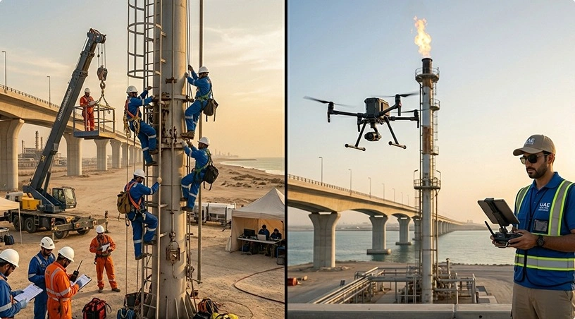
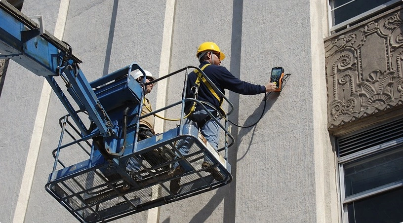
Direct labor and access costs. A facade or roof inspection using rope access typically requires a certified team of two to four technicians, a safety supervisor, and rigging setup time that can consume half a day before any inspection work begins. Scaffolding-based inspections add material transport, erection, and dismantling costs that can run into five figures for a single building. On high-rise projects in Dubai or Abu Dhabi, these access costs often exceed the cost of the inspection itself.
Schedule impact and downtime. Manual inspections create exclusion zones. The area being inspected, whether it is a facade, a rooftop, or a structural element at height, is typically cordoned off for safety. Other trades cannot work in that zone during the inspection. On a fast-track project with overlapping activities, this downtime cascades. A two-day facade inspection that blocks cladding or MEP work in the adjacent zone has a cost that never appears on the inspection invoice but shows up in the project schedule.
Data limitations. A technician on a rope or scaffold inspects what is directly in front of them. Coverage is sequential, subjective, and limited by the physical path they can access. Documentation is typically a combination of photos taken on a phone, handwritten notes, and a report compiled afterward. The result is a partial record that is difficult to compare across inspection cycles and nearly impossible to geo-reference precisely. When a defect is flagged, locating it again months later for follow-up often requires repeating the access setup.
Safety exposure. Working at height remains one of the leading causes of serious injury on construction sites globally. Every hour a technician spends on a scaffold or rope system is an hour of exposure to fall risk, regardless of how well-managed the safety protocols are. In the UAE’s summer months, heat stress compounds this risk significantly, limiting productive working hours and requiring additional crew rotation.
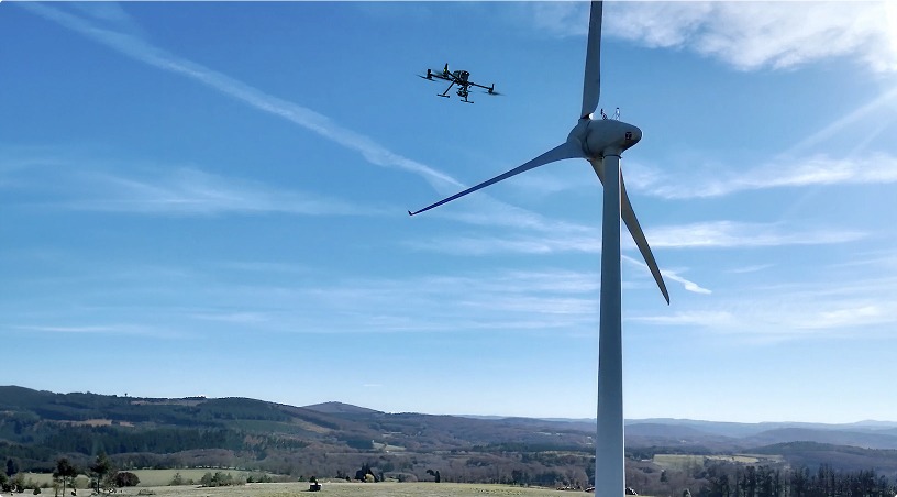
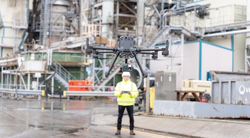
Aerial inspection consolidates many of the cost elements listed above into a single, faster operation. An enterprise-grade aerial platform equipped with high-resolution visual and thermal sensors can capture a building facade, rooftop, or multi-structure site in a fraction of the time required for manual methods.
Mobilization and capture. A typical building inspection using an aerial platform requires a certified pilot, a planned flight path, and coordination with site operations. Mobilization takes hours rather than days. There is no scaffolding to erect, no rope rigging to install, and no exclusion zone that blocks other trades for extended periods. A facade survey that would take two to three days with rope access can often be completed in a single sortie.
Data processing and deliverables. Raw imagery is processed through photogrammetry and analytics software to produce geo-referenced orthomosaics, 3D point clouds, and annotated defect maps. Thermal data captured simultaneously identifies insulation failures, moisture ingress, and temperature anomalies that visual inspection alone would miss. The deliverables are structured, repeatable, and organized in centralized platforms where project teams can review, measure, and compare findings across inspection cycles without re-mobilizing to the site.
Per-inspection cost comparison. The direct cost of a drone-based inspection is typically 60 to 75 percent lower than the equivalent manual method when scaffolding or rope access is involved. This figure accounts for mobilization, capture, processing, and reporting. When you factor in the avoided schedule downtime and the reduced safety exposure, the effective savings are even higher. For projects with recurring inspection requirements, such as monthly progress monitoring or quarterly condition assessments, the cumulative cost difference over the project lifecycle becomes substantial.
A fair cost-benefit analysis recognizes that drone-based inspection does not replace every function of manual assessment. There are scenarios where physical access to a surface remains necessary.
Close-contact testing. Inspections that require physical interaction with the surface, such as adhesion pull tests on coatings, hammer sounding for delamination, or moisture meter readings at specific points, still need a technician on site. Aerial data cannot replicate tactile assessment.
Confined spaces and interior work. While robotic systems are beginning to address some interior inspection scenarios, most drone-based inspection today focuses on exterior and aerial-access surfaces. Interior structural inspections, utility corridor assessments, and below-grade work typically require personnel access.
Regulatory or contractual requirements. Some inspection standards and client specifications still mandate physical presence or specific testing protocols that aerial methods cannot satisfy. In these cases, manual inspection remains the required approach regardless of cost.
The practical strategy for most UAE construction projects is not an either/or decision. It is a hybrid model where aerial inspection handles the high-volume, high-access, repeatable data capture, and manual inspection is reserved for the targeted, contact-based assessments that genuinely require physical presence. This combination reduces overall inspection costs while maintaining compliance with project specifications.
This is where the comparison often surprises project managers who have not yet worked with aerial inspection data.
Manual inspection produces a subjective, partial record. The quality depends entirely on the individual technician’s experience, the conditions during the inspection, and the consistency of their documentation. Two different inspectors examining the same facade will produce different reports, focus on different areas, and photograph different details. There is no standardized spatial reference tying their observations to a precise location on the building.
Aerial inspection produces a consistent, geo-referenced, full-coverage dataset. Every image is tied to GPS coordinates. Every thermal reading maps to a specific point on the structure. Because the flight path is predefined and repeatable, subsequent inspections capture the same areas from the same angles, enabling direct comparison over time. AI-assisted analytics classify defects by type and severity, replacing subjective judgment with standardized categorization that is consistent across inspectors, sites, and reporting periods.
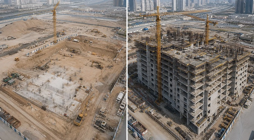
For project managers, this data quality difference has a direct operational impact. Progress monitoring built on repeatable aerial captures produces visual evidence that supports schedule verification, dispute resolution, and stakeholder reporting. Volumetric measurements from photogrammetry deliver survey-grade accuracy for stockpile tracking and progress billing. And trend analysis across multiple inspection cycles reveals degradation rates and maintenance needs that single-point manual assessments simply cannot provide.
The structured, centralized nature of aerial inspection data also solves the fragmented documentation problem. Instead of photos scattered across phones and reports filed in different folders, all inspection outputs sit in one platform with measurement tools, side-by-side comparison, and controlled stakeholder access built in.
The cost-benefit comparison between drone and manual inspection is not abstract. It translates directly into budget, schedule, safety, and data quality outcomes that UAE project managers deal with on every project. To recap:
Aerial inspection reduces direct inspection costs by 60 to 75 percent compared to scaffolding and rope access methods, with additional savings from avoided schedule downtime and reduced safety exposure. Data quality shifts from partial, subjective documentation to full-coverage, geo-referenced, repeatable datasets that support evidence-based decisions. Manual inspection retains value for close-contact testing, interior work, and specific regulatory requirements, making the optimal approach a hybrid model rather than full replacement. And centralized data platforms eliminate fragmented documentation by organizing every capture, measurement, and comparison in one accessible location.
For project managers looking to reduce inspection costs without sacrificing data quality or compliance, the framework is straightforward: aerial for coverage, manual for contact, and a centralized platform to tie it all together.
Gulfnet delivers drone services for construction sites across the UAE and wider GCC, including progress monitoring, building inspections, stockpile surveys, and 3D mapping. Our certified operations, enterprise-grade platforms, and analytics tools help project teams capture better data, faster, at a fraction of the cost of traditional methods. Request a consultation to scope your next inspection cycle.
How much cheaper are drone inspections compared to scaffolding-based methods on UAE construction projects?
Drone-based inspections typically cost 60 to 75 percent less than equivalent scaffolding or rope access methods. This accounts for mobilization, capture, processing, and reporting. The savings increase further when factoring in avoided production downtime and reduced safety exposure across recurring inspection cycles throughout the project lifecycle.
Can drone inspections fully replace manual building inspections on construction sites?
Not entirely. Drone inspections handle high-access exterior surveys, progress monitoring, and thermal assessments with greater speed and coverage. However, close-contact testing like adhesion pull tests, hammer sounding, and interior inspections still require physical presence. The most effective approach combines aerial coverage with targeted manual assessments.
What data do construction project managers receive from a drone-based building inspection?
Deliverables include geo-referenced orthomosaics, high-resolution annotated imagery, 3D point clouds, thermal analysis reports, and severity-classified defect maps. All outputs are organized in centralized platforms with measurement tools and side-by-side comparison features, enabling teams to track changes across inspection cycles without returning to site.
Are drone inspections on UAE construction sites compliant with GCAA aviation regulations?
Yes. All operations follow General Civil Aviation Authority regulations. Certified pilots hold required credentials, and site-specific flight permits are secured before every mission. Coordination with site teams ensures flights integrate safely with active crane operations, personnel movement, and ongoing construction activities across the project.
How long does a drone inspection take compared to a manual facade or roof inspection?
A facade or rooftop survey that requires two to three days using scaffolding or rope access can typically be completed in a single aerial sortie lasting a few hours. Data processing and structured reporting follow within 24 to 48 hours, significantly compressing the overall inspection-to-decision timeline for project teams.
 Go back