If your construction site still measures stockpiles with tape, total stations, or wheel-based estimations, you are almost certainly dealing with volume discrepancies that affect progress billing, material reconciliation, and earthwork cost control. On large sites with multiple active stockpiles of aggregate, sand, fill, and excavated material, even a five percent measurement error compounds into significant financial exposure over the course of a project. The problem is not that traditional methods are fundamentally flawed. It is that they are slow, labor-intensive, sample-based, and difficult to repeat consistently across reporting periods.
This blog explains how aerial photogrammetry-based volumetric measurement works, what accuracy it delivers on real construction sites, and how it solves the specific quantity control challenges that project managers, quantity surveyors, and commercial teams deal with on UAE and GCC projects.
The challenge with conventional stockpile measurement is not a single point of failure. It is an accumulation of limitations that, taken together, produce data that is difficult to trust and even harder to defend in a commercial dispute.
Time and site disruption: Measuring multiple stockpiles manually is time-consuming. A busy construction site with ten or more active piles can require a full day of survey work, during which equipment access to those piles may be restricted. Material deliveries, loading operations, and earthmoving activities either pause or create a moving target that invalidates the measurement. The practical result is that stockpile surveys happen infrequently, often monthly, leaving weeks of material movement unaccounted for between measurements.
Inconsistency across cycles: When different surveyors measure the same stockpile on consecutive cycles, they make different judgment calls about where to place points, where the pile boundary begins, and how to handle irregular shapes. This variability makes it difficult to compare volumes meaningfully across reporting periods. A quantity surveyor reviewing consecutive measurements cannot confidently distinguish genuine material consumption from measurement inconsistency.
Commercial exposure: Stockpile volumes drive progress billing for earthwork and material supply contracts. When the contractor’s volume measurement differs from the client’s independent check, the resulting dispute delays payment, consumes project management time, and erodes trust between parties. On projects where material quantities represent millions of dirhams in contract value, measurement credibility is not a technical nicety. It is a commercial necessity.
Aerial volumetric measurement uses photogrammetry to build a detailed three-dimensional model of each stockpile, from which volume is calculated computationally rather than through manual interpolation.
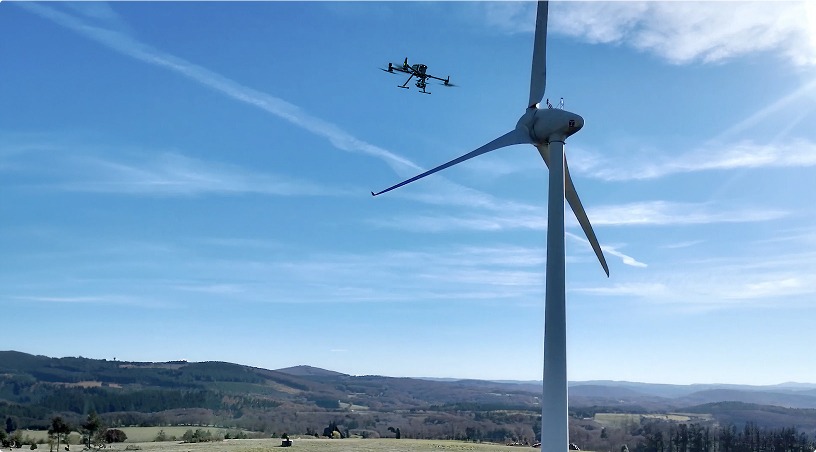
The process begins with a planned flight. An enterprise-grade aerial platform flies a predefined path over the stockpile area, capturing hundreds of overlapping high-resolution photographs from multiple angles and altitudes. Ground control points placed around the survey area provide geo-referencing accuracy, tying the imagery to known coordinates.
These overlapping images are processed through photogrammetry software that identifies matching features across photographs and reconstructs the scene as a dense three-dimensional point cloud. Unlike a ground-based survey that captures dozens or hundreds of points per stockpile, the photogrammetric point cloud contains hundreds to thousands of points per square meter depending on survey parameters. Every contour, ridge, depression, and edge of the pile is represented in the model.
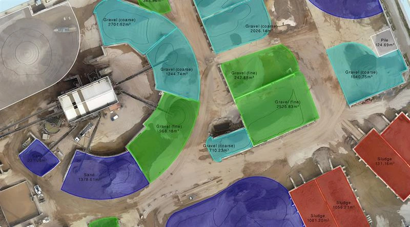
From the point cloud, the software generates a digital surface model (DSM) of the stockpile. The volume is then calculated by defining a base plane, typically the ground surface surrounding the pile, and computing the volume of material between that base and the modeled surface. The calculation accounts for the full three-dimensional shape of the pile, including concavities and irregular geometry that ground surveys miss.
The entire data capture for a site with multiple stockpiles typically takes a fraction of the time required for ground-based measurement. Processing follows within hours to days depending on the number of piles and the level of reporting required. Deliverables include volume calculations, surface area measurements, geo-referenced orthomosaic imagery of each pile, and comparison reports against previous survey cycles.
Accuracy is the question that matters most to quantity surveyors and commercial teams, and it is where aerial measurement earns its credibility.
Photogrammetry-based volumetric capture typically delivers accuracy within one to three percent of the actual volume when proper ground control points are deployed and the survey follows established methodology. This is comparable to, and in many cases better than, the accuracy achievable with ground-based total station surveys on large, irregularly shaped stockpiles, where interpolation between sparse measurement points introduces its own error margin.
Several factors influence the achievable accuracy on any given site. Ground control point density and distribution matter: control points placed at consistent intervals around the survey area provide the positional reference that keeps the photogrammetric model aligned with real-world coordinates. Flight altitude affects ground sampling distance, which determines the level of surface detail captured. And processing parameters, including point cloud density and filtering settings, influence how faithfully the digital model represents the physical stockpile.
For construction sites in the UAE and GCC where environmental conditions include high ambient temperatures, dust, and wind, flight planning accounts for these variables to ensure data quality. Surveys are scheduled during optimal lighting conditions, and ground control placement follows protocols designed for the specific terrain and pile configurations on each site.
The repeatability of the method is equally important. Because the flight path is predefined and the processing workflow is standardized, consecutive surveys capture the same stockpiles in the same way. This eliminates the surveyor-to-surveyor variability that undermines confidence in traditional methods. When a quantity surveyor compares volumes from one reporting period to the next, the differences reflect actual material movement, not measurement inconsistency.
The value of precise stockpile measurement extends beyond the survey report. It connects directly to the financial and operational workflows that drive construction project delivery.
Progress billing verification: On earthwork and material supply contracts, payment milestones are tied to quantities. When both the contractor and the client reference the same aerial survey data, volume disputes are reduced or eliminated. The geo-referenced imagery provides visual evidence that supports each measurement, making the data auditable and defensible. For projects with multiple material types and active stockpile areas, this transparency accelerates payment cycles and reduces the commercial friction that consumes project management bandwidth.
Material reconciliation and loss control: Comparing aerial volumetric data against delivery records and usage logs reveals discrepancies that indicate material loss, theft, or accounting errors. On sites receiving hundreds of truckloads per week, the ability to verify that delivered quantities match measured stockpile growth provides a control mechanism that manual methods cannot replicate at scale. Repeat surveys at regular intervals create a material flow record that procurement and logistics teams can use for forecasting and vendor management.
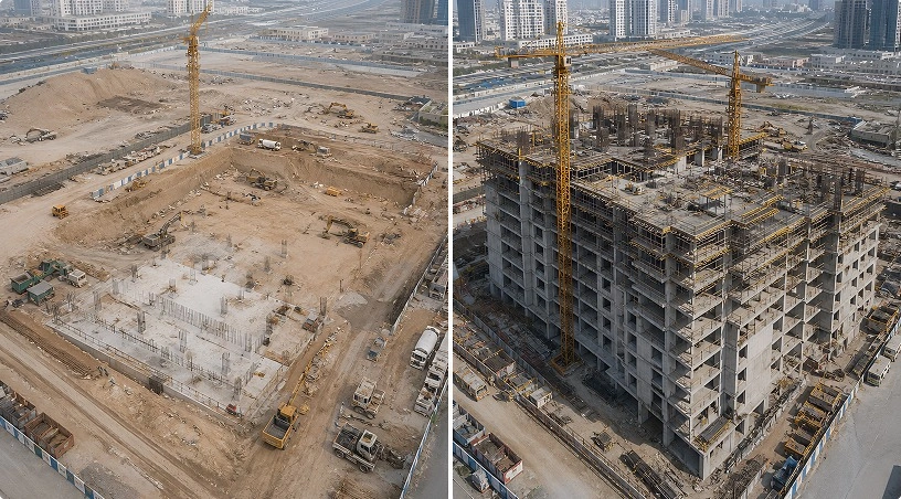
Earthwork quantity control: Cut-and-fill calculations derived from aerial survey data support accurate tracking of excavation and fill operations. Digital terrain models generated before, during, and after earthwork phases show exactly how much material has been moved, where it came from, and where it was placed. This supports both internal project controls and external reporting to clients and consultants. For large infrastructure and development projects where earthwork represents a major cost center, the accuracy of this data directly affects the project’s financial outcome.
Centralized data access and stakeholder sharing: All volumetric data, imagery, and comparison reports are organized in analytics platforms where project teams can review measurements, take additional on-screen calculations, and share controlled access with clients, consultants, and auditors. This replaces the fragmented documentation approach where survey reports, photos, and calculations sit in separate files and email threads. Having every measurement cycle accessible in one place, with side-by-side comparison tools built in, gives commercial and technical teams a shared reference point for every quantity discussion.
Drone-based volumetric measurement solves the specific data quality and efficiency problems that undermine stockpile management on construction sites. To recap:
Photogrammetry produces dense, three-dimensional surface models that capture the full geometry of each stockpile, eliminating the interpolation gaps inherent in ground-based methods. Accuracy within one to three percent, combined with standardized, repeatable flight paths and processing workflows, gives commercial teams measurement data they can trust and defend. Regular survey cycles create a historical record of material movement that supports progress billing, material reconciliation, and earthwork cost control. And centralized data platforms organize every survey, measurement, and comparison in one accessible location for all project stakeholders.
For project managers and quantity surveyors operating on sites where material volumes drive contract value, the shift from sample-based ground measurement to full-coverage aerial survey is not just a technology upgrade. It is a commercial risk reduction strategy.
Gulfnet provides surveying, mapping, and measurement services for construction and infrastructure projects across the UAE and GCC, including stockpile volumetric measurement, cut-and-fill analysis, topographic surveying, and aerial photogrammetry. Our enterprise drone platforms, certified operations, and data processing workflows deliver survey-grade outputs that support quantity control, billing verification, and engineering decisions. Request a consultation to scope your next stockpile survey.
How accurate are drone-based stockpile volume measurements compared to traditional ground surveys?
Drone-based photogrammetry typically delivers volumetric accuracy within one to three percent when proper ground control points are deployed. This is comparable to or better than ground-based total station methods on large, irregular stockpiles, where interpolation between sparse measurement points introduces its own error margin into volume calculations.
How long does a drone stockpile survey take on a construction site with multiple piles?
Aerial data capture for a site with multiple stockpiles typically completes in a fraction of the time required for ground-based measurement. A site that would take a full day using traditional methods can often be captured in one to two hours. Processing and volume reporting follow within hours to days depending on project scope.
Can drone volumetric surveys be conducted on active construction sites without stopping operations?
Yes. Aerial surveys are non-intrusive and designed to work around active site conditions. Flights are coordinated with site management to avoid interference with loading, hauling, and earthmoving operations. Material deliveries and equipment movement continue normally during data capture, eliminating the operational pauses that ground-based surveys often require.
What deliverables do quantity surveyors receive from a drone stockpile survey?
Deliverables include volume calculations for each stockpile, surface area measurements, geo-referenced orthomosaic imagery, digital surface models, and comparison reports against previous survey cycles. All outputs are organized in centralized platforms with on-screen measurement tools and controlled stakeholder access for billing verification and audit purposes.
How often should stockpile volumetric surveys be conducted for reliable quantity control?
Survey frequency depends on material movement rates and reporting requirements. Most construction projects benefit from biweekly or monthly surveys during active earthwork and material delivery phases. The low cost and minimal disruption of aerial surveys makes higher frequency practical, enabling project teams to track material consumption closely and catch discrepancies early.
 Go back