A 5G site that should have gone live last week is still waiting on a structural sign-off. The climb crew was rescheduled twice, the antenna mount condition is still unconfirmed, and the activation date has now moved into next month. For rollout managers across UAE telecom operators, this is the recurring story of 4G densification and 5G expansion: the equipment is on site, the integration team is ready, and the inspection layer is the part that keeps slipping.
This blog walks through where conventional tower inspection breaks down under rollout pressure, which defects most often hold activation, how a drone-led inspection cycle reshapes the timeline, and what UAE-specific operating conditions mean for any operator planning a serious expansion programme over the next two to three years.
A typical macro tower climb takes a two-person team most of a working day once travel, permit-to-work paperwork, harness checks, and weather windows are accounted for. Multiply that across hundreds of sites during a regional 5G rollout and the inspection backlog itself becomes the rate-limiting step. Rope access crews are a finite resource in the UAE, and the qualified ones are heavily contracted to oil and gas, utilities, and infrastructure clients simultaneously. The result is that survey reports arrive late, antenna mount conditions are only confirmed after the install team is already on site, and rework on bolt torque, corrosion, or grounding gets discovered after activation rather than before.
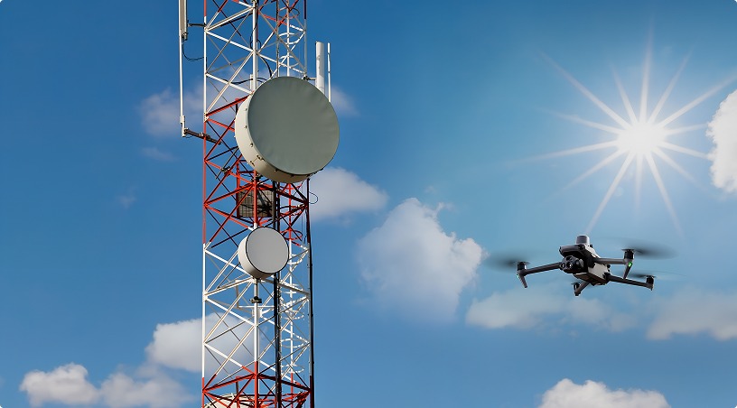
Aerial inspection shifts this equation. A trained pilot team operating an industrial drone can complete a full visual, thermal, and structural inspection of a 60 metre tower in well under an hour, with no climb permit required and no site shutdown.
Across pre-activation audits, a small set of issues account for the majority of commissioning delays. Antenna azimuth and tilt drift on legacy 4G mounts, corrosion at bolted connections especially in coastal sites, deteriorating earthing strap connections, and damaged or missing climb-safe equipment are the recurring findings. On newer 5G installations, the failure modes shift toward overheating remote radio units, loose waveguide clamps, and shading from co-located equipment that affects beamforming performance.
The challenge is that several of these defects are invisible from the ground and difficult to confirm by climb alone. Thermal imaging can quickly identify abnormal temperature patterns that may indicate cooling, loading, or equipment health issues.
A high resolution visual capture documents corrosion patterns and bolt conditions without subjective judgment from the rope team. Photogrammetric processing can assist engineering teams in assessing clearances, structural geometry, and antenna positioning.
A drone-led inspection cycle works across four stages of the tower lifecycle. Pre-deployment surveys establish the structural baseline and confirm that the tower can carry the proposed new load before procurement decisions are locked in. Mid-rollout commissioning inspections verify mount integrity, cable routing, and thermal signatures on the new equipment within days of installation rather than weeks. Post-incident response inspections, particularly after the seasonal shamal winds or unusually heavy rain events, identify storm damage without dispatching climb teams to every site in the affected zone. Ongoing preventive inspections on a defined interval catch slow-developing issues such as corrosion progression or fastener loosening before they escalate.
This cycle becomes useful only when the data feeds back into the operator’s asset management system in a usable format, which is where structured data processing matters as much as the flight itself.
Also read: Wind Turbine Inspection: How Drones Are Transforming Maintenance
Inspection work in the UAE is not the same as inspection work in cooler, less regulated environments. Ambient temperatures above 45 degrees Celsius in summer affect both drone battery performance and thermal imaging baselines, which has to be accounted for during flight planning and during defect interpretation. Coastal humidity and airborne particulates accelerate corrosion on towers along the Gulf coastline, making the realistic inspection interval shorter than international benchmarks would suggest. Urban deployments in Dubai and Abu Dhabi involve dense controlled airspace around DXB, AUH, and Al Maktoum, requiring GCAA authorisation and coordination through the CAR Airspace Part Uspace framework before any flight.
These are not theoretical concerns. They are the reason a tower inspection programme in the UAE needs pilots who are GCAA-certified, flight plans cleared through the proper regulatory channels, and operators who understand the local environmental load on telecom assets. Generic aerial inspection providers without UAE telecom or regulatory experience tend to discover this gap on their first project.
Related: Power Line Inspection with Drones: A Smarter Approach for UAE Utilities
Capture is the easy part. Turning thousands of images, thermal frames, and point cloud data into a defect register that engineering and field teams can act on is where most inspection programmes stall. The patterns that work involve a defined defect taxonomy aligned to the operator’s existing asset codes, AI-assisted triage to surface high-priority anomalies first, and outputs delivered in formats that drop directly into the operator’s ticketing and works management system. The objective is that a site visit by a remediation crew lands with a specific work order, not a folder of photographs to interpret on arrival.
Done well, this approach compresses the survey-to-remediation cycle from weeks to days and gives rollout managers a defensible view of which sites are ready for the next phase.
The pressure on UAE telecom operators to expand 4G coverage in underserved zones and accelerate 5G activation across urban and industrial corridors is not slowing. Inspection capacity, not equipment supply, is the constraint most likely to slip a rollout schedule this year. A structured aerial inspection programme run by GCAA-certified pilots, supported by thermal and high resolution visual capture, photogrammetric processing, and AI-led data triage, addresses that constraint directly while producing a richer asset record than climb-only surveys ever could.
To discuss an inspection programme tailored to your network expansion timeline, including pre-deployment audits, commissioning checks, and ongoing preventive cycles supported by Gulfnet Insight analytics, get in touch with the Gulfnet Drones and Robotics team.
How long does a drone inspection of a telecom tower take in the UAE?
A standard macro tower inspection typically takes 45 to 90 minutes on site for capture, depending on tower height, number of antenna sectors, and required thermal passes. Data processing and defect reporting through analytics platforms usually adds two to five working days, depending on overall programme volume and reporting requirements.
Do telecom tower drone inspections require GCAA approval?
Yes. Any commercial drone operation in the UAE requires GCAA authorisation, certified pilots, and an approved flight plan, particularly near controlled airspace or sensitive infrastructure. Telecom tower inspections in urban zones additionally need coordination through the CAR Airspace Part Uspace framework before any flights are cleared for execution.
Can drone inspections detect issues that climb surveys miss?
Aerial inspection captures thermal signatures of remote radio units, overhead structural conditions, and angular antenna alignment that are difficult to assess accurately from a climb position. Combined with photogrammetric processing, it produces measurable 3D records that support engineering review well beyond what a single climb visit documents on its own.
How often should 4G and 5G tower sites be inspected?
Annual structural and RF asset inspections are the working baseline in the UAE, with shorter intervals for coastal sites exposed to salt-laden humidity and corrosion. Post-storm inspections after major weather events, plus commissioning inspections after any equipment swap, are increasingly standard for operators managing dense urban networks.
Is drone inspection cost-effective for large network rollouts?
For rollouts spanning hundreds of sites, aerial inspection typically lowers total survey cost by reducing climb hours, eliminating return visits to confirm findings, and avoiding rework discovered after activation. The bigger commercial impact is usually faster site activation, which protects rollout milestone commitments and associated revenue timing.

 Go back