
Building a 3D digital twin from drone data sounds straightforward: fly the asset, process the scan, hand over the model. In practice, most UAE infrastructure operators end up with a large 3D file that maintenance teams cannot use to plan work, track defects, or schedule inspections. The gap between a delivered scan and a working digital twin is where most twin programmes lose their value. This blog covers how a 3D digital twin should be built from drone data for UAE infrastructure: the four layers that make it a decision tool rather than a dataset, and what operators in oil and gas, utilities, and infrastructure need to specify from the start to get real asset intelligence out of the programme.
The dataset problem starts long before the drone flies. A point cloud is not a digital twin. Neither is a textured mesh, an orthophoto map, or a BIM export. These are inputs. What operators actually need is a model where each part of the asset carries its own tag, its own inspection history, and a link to the maintenance record. Across our UAE operations we routinely see programmes stall at handover: the scan is technically accurate, but nothing downstream can use it. Engineering teams cannot pull tag numbers. Inspection planners cannot compare last quarter to this one. The twin sits as a file, not as a working tool./p>
The reason usually traces back to a decision made before takeoff. Flight settings were chosen for pretty pictures, not for measurement. Coordinate systems were not agreed. No one specified how the model would connect to the maintenance system. According to a McKinsey analysis of digital twin adoption in industrial operations, most twin projects underdeliver because organisations treat them as picture-making exercises rather than data projects.
If a twin is more than a picture, what does the working version look like? It is built in four layers, and each has to be planned from the start.
The first layer is geometry: a mapped 3D reconstruction of the asset, usually built from photogrammetry or LiDAR capture. The second is identity, where each pipe, valve, cable, or panel is tagged and linked to the asset register. The third is condition, where defects, hot spots, and corrosion signs are attached to the specific part they affect. The fourth is time, where the twin refreshes on a set schedule so that change becomes visible and traceable.
Most datasets delivered in the UAE market stop at layer one. Everything above it needs processing discipline, agreed tagging rules, and a platform that can hold condition data against the geometry. That is the work that turns a scan into asset intelligence.
The geometry layer is only as good as the flight that produced it. Image overlap, ground control point placement, camera resolution, and payload choice all decide whether the finished model can support real measurement or only a visual check. On a wind turbine blade or a flare stack, that difference is the difference between spotting a millimetre-wide crack and missing it.
Our capture standards on managed programmes specify overlap thresholds, ground control density, and thermal payload configuration by asset type, because the requirements for an offshore platform are not the requirements for a substation yard.
Our blog on Wind Turbine Inspection Services, details how capture parameters shift when the asset itself is moving. Flight planning also has to work around GCAA airspace approvals, and any twin programme needs to build those approval windows into the delivery schedule.
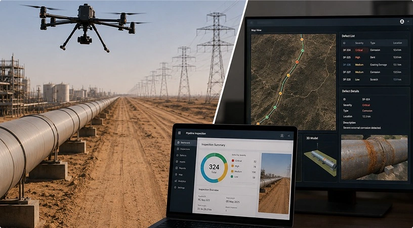
Once the geometry is captured to standard, the twin still cannot answer operational questions. It needs the identity and condition layers. This is where an AI-powered analytics layer sits: defect classification, thermal deviation flagging, and part-level condition scoring attached directly to the 3D model. An operations manager should be able to click a coupling on the twin and see when it was last inspected, how its temperature is trending, and which work order was raised against it.
Getting there needs a tagging rule agreed at project start, a defect list that matches the operator’s maintenance codes, and a processing pipeline that can classify at volume. Manual tagging does not survive the volume of data a large-site capture produces.
The same side of the question is covered in our blog DJI Enterprise Drones for Industrial Inspection.
A twin enriched with condition data still ages. One that reflects the asset as it was eighteen months ago is a historical record, not a decision tool. The fourth layer, time, is what keeps it useful. For high-change environments such as active construction sites or offshore platforms under modification, monthly or quarterly recapture is standard. For steadier assets such as transmission corridors, an annual update with extra flights after storms or incidents is usually enough.
Change detection is where the twin earns its keep. Comparing successive scans surfaces settlement, deformation, corrosion growth, and unauthorised additions to the site. Guidance from the International Association of Oil and Gas Producers notes that catching structural change early reduces both unplanned downtime and incident severity. Change detection at the twin level puts that principle into daily practice.
Because the twin has to be captured, enriched, and refreshed on a cycle, it is a programme rather than a one-off delivery. That means agreed capture schedules, agreed processing standards, and agreed connection points with the operator’s asset management system. GCAA-certified pilot teams, dock-based autonomous drones for routine recapture, and a strong engineering team on the processing side are what turn the plan into a running service. The commercial question is not the price of the first scan. It is the cost per useful decision the twin supports over its life.
The path from drone data to asset intelligence runs through four layers: geometry, identity, condition, and time. Skip one and the twin stops being a decision tool. Operators who plan for all four from the start get real value: fewer surprises in the field, tighter capital planning, and defect histories that stay with the asset even when staff change.
If you are evaluating a digital twin programme for your UAE assets, Gulfnet Emirates delivers end-to-end capture, processing, and analytics as a managed service for enterprise operators.
What is a 3D digital twin for infrastructure?
A 3D digital twin is a mapped, searchable model of a physical asset that combines accurate geometry with part-level condition and maintenance data. For UAE infrastructure, it links drone-captured geometry to inspection records and asset registers so operations teams can make decisions against a live model rather than static drawings.
How long does it take to build a digital twin from drone data?
Timelines depend on asset size and update cadence. A single substation twin can be delivered in two to three weeks from capture to enriched model. Larger sites such as offshore platforms or transmission corridors typically run four to eight weeks for the first build, with recapture cycles then scheduled monthly, quarterly, or annually.
What drone data is needed for a digital twin?
High-overlap RGB imagery for photogrammetry, LiDAR for dense geometry, and thermal payload capture for condition data. Ground control points and RTK positioning support survey-grade accuracy. Payload choice depends on the asset type. Gulfnet Emirates sets capture parameters by asset class so the resulting dataset can carry the intended engineering use.
How accurate are drone-based digital twins?
Accuracy depends on capture standards and processing discipline. Well-planned photogrammetry with proper ground control routinely reaches an absolute accuracy of two to five centimetres, with relative accuracy tight enough for defect measurement. LiDAR-based twins can reach millimetre-level detail on components. Accuracy claims should always be tied to a documented capture and processing standard.
Which UAE sectors benefit most from digital twin development?
Oil and gas, power and utilities, marine and ports, telecoms infrastructure, and large-scale construction all benefit. Any operator managing high-value assets across dispersed sites gains from a twin that consolidates condition data. Gulfnet Emirates delivers twin programmes across all seven emirates for enterprise clients running managed inspection and asset intelligence workflows.

 Go back